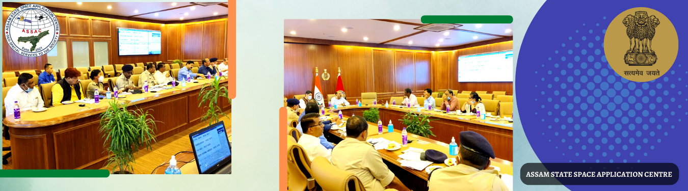
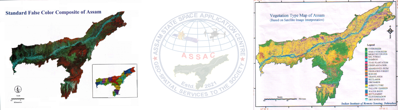
Assam State Space Application Centre (ASSAC) Guwahati was established as an autonomous body under the administrative control of Science Technology and Climate Change Department, Government of Assam. ASSAC was formerly known as Assam Remote Sensing Application Centre (ARSAC) a core division of Assam Science Technology and Environment Council (ASTEC) and was working in the field of Remote Sensing (RS) and Geographic Information System (GIS) since 1988 with an objective to : Develop remote sensing techniques and their applications for natural resources management in the state Provide training and consultancy facilities in remote sensing to the user agencies. Equipped with both visual as well as digital interpretation tools, ARSAC has successfully completed a number of projects as partner institute with Indian Space Research Organisation (ISRO) under various national missions of Department of Space (DOS), Govt. of India and customized data as per necessity for various user agencies/ line departments of Govt. of Assam as well as involved in preparation of their development plans with geometric accuracy based on data and information through application of Remote Sensing and Geographical Information System (GIS). The Govt. of Assam vide Memo No. STE 86/2016/93A dtd. 23rd March, 2018, has declared ARSAC as the Nodal Agency for all Remote Sensing(RS), Geographical Information System(GIS) and Global Positioning System (GPS) related work and procurement and supply of satellite data for the State of Assam. Also, ARSAC would act as the centralized location for creating, storing, analyzing, retrieving and supply of the spatial data to all the user departments of Assam Government. The Hon'ble Cabinet has taken a decision to establish Assam State Space Application Centre (ASSAC) by carving out Assam Remote Sensing Application Centre (ARSAC) from Assam Science Technology and Environment Council (ASTEC). The decision taken by the Hon'ble Cabinet held on 28-07-2021 and subsequently Hon’ble Cabinet held on 06.10.2021 approved for Establishment of ASSAC Society at Guwahati under Societies Registration Act,1860. At present ASSAC has a repository of Geospatial databases comprising village/city cadastral database administrative boundaries and a wealth of natural resources databases generated using satellite Remote Sensing and GIS technology at various scales. As a recent mandate assigned by Govt. of Assam, ASSAC is working on a strategy for using such vast databases in shared mode by the State as well as Central Government departments for geospatial services in G2G & G2C domains. Accordingly ASSAC will provide technical support and assistance to various departments under Assam for all their Geospatial activities and provide them a decision support system (DSS) which will be useful to them in their day-to-day activities.
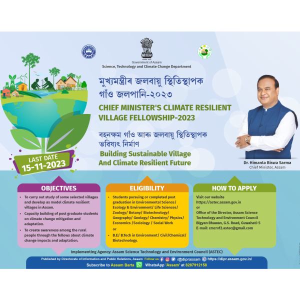
The Chief Minister's Climate Resilient Village Fellowship Programme, launched in 2022 by Science Technology and Climate Change Department, Government of Assam, is a significant initiative being implemented by the Assam Science Technology and Environment Council. Its primary goal is to enhance climate resilience and sustainable development in rural communities of Assam. Emphasizing the importance of innovation, technology adoption in a phased manner and strong leadership, the Honorable Chief Minister of Assam aims to address climate change in line with Sustainable Development Goal 13 (SDG-13). The Programme targets the participation of 100 post-graduate science students and engineering graduates, who will study climate change impacts and potential solutions in 100 villages in phased manner. The selected fellows will receive one time fellowship of Rs. 20,000, along with training, resources, support, and guidance from scientific institutions to implement innovative climate change solutions in their respective villages.
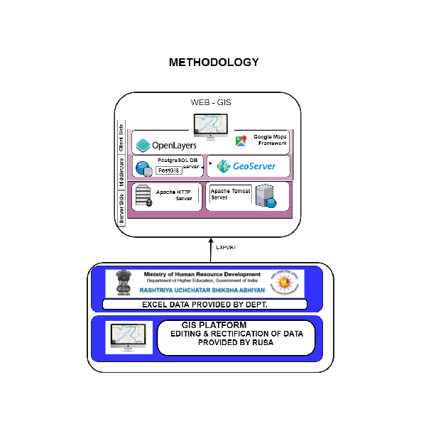
The key objectives of RUSA were to improve access, equity and quality in higher education through planned development of higher education at the state level. Objectives include creating new academic institutions, expanding and upgrading the existing ones, developing institutions that are self-reliant in terms of quality education, professionally managed, and characterized by greater inclination towards research and provide students with education that is relevant to them as well the nation as a whole. The digital mapping of educational institutions along with the ward/village boundary, road access and major settlement provides the ground reality in terms of spatial and social coverage of institutes with respect to population density
This project, titled "Mapping and Geo-tagging of SATTRA and Archaeological sites of Assam using Mobile apps," aims to preserve and promote the rich cultural and historical heritage of Assam. The project encompasses the entire state and focuses on SATRA institutions and Archaeological sites and to generate a Web GIS application. In Phase-I of this activity 4 (four) districts are prioritised by Directorate of Archaelogy, Department of Cultural Affairs, Governemnt of Assam viz. Kamrup(M), Kamrup, Majuli and Sibasagar. The background of the project highlights the creation of the geospatial database which can facilitate governance and developmental planning. The scope and objectives of the project include geo-tagging SATTRAS and Archaeological sites using a Mobile App for four (4) prioritised districts identified by Directorate Archaeology, Assam. The materials and methods section outline the data collection process, which involves using a mobile app to collect site information, including names, locations, dimensions, photographs, road details, and land use patterns. In conclusion, this project seeks to leverage technology and data collection to create a comprehensive digital archive and map of SATRA and Archaeological sites, preserving and promoting Assam's cultural heritage. Number Sattras and Archaelogical sites Geotagged are 177 and 56 numbers respectively for 4 districts i.e. Kamrup, Kamrup(M) ,Sibasagar (including Charaideo) and Majuli . Out of 177 numbers of Sattras 156 nos. are as per the list shared by the department and remaining 21 numbers are categorised as Other .
Click here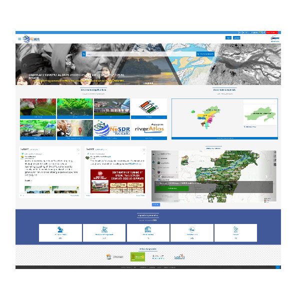
The NeSDR is one of the major programme of NESAC taken up as per the directive of North Eastern Council (NEC)/Ministry of DoNER with the objective to establish Geospatial Network among State Remote Sensing Applications Centres (SRSACs) of NE region through augmentation of existing IT infrastructures as well as creating the catalogue of existing geospatial data generated at different scales, different time frame available with SRSACs or user and line departments. NESAC as Central Node hosts regional database including State data whereas respective State Node will be responsible for State data generated by SRSACs or other Line Departments. The communication link between Central Node and respective State Node is through Virtual Private Network (VPN) to enable data cataloguing, sharing, retrieving etc. in a decentralized mode from respective State Nodes. NeSDR facilitates users to visualize, retrieve, Geo-process and publish geospatial layers of interest through online registration via secure authentication gateway.
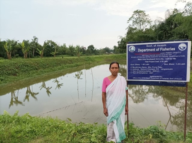
The project titled "Application of Geospatial Technology for Mapping and Identification of Fishery Resources in Kamrup District" was sponsored by the Department of Fisheries, Assam, with the primary aim of creating a detailed spatial database using remote sensing and GIS technologies. This database focuses on aquatic habitats, such as rivers, ponds, wetlands, and reservoirs, to visualize the distribution of fishery resources for conservation and management purposes. In the 9th meeting of the NESAC Society in January 2021, it was proposed to expand the use of geospatial technology in various sectors across North East India to enhance regional infrastructure and sectoral development. This initiative, known as the "Plan of Action (PoA)," was led by the Honourable Home Minister, Shri. Amit Shah. The project commenced on May 24, 2022, with the signing of terms of reference between the Department of Fisheries and the Assam State Space Application Centre. It relies on advanced GIS and remote sensing technology, utilizing high-resolution Maxar and Airbus satellite data from the "Google Hybrid" platform and medium-resolution LISS-IV data from NRSC. The mapping was done at a 1:800 scale, and a total of 34,025 fisheries were mapped in Kamrup district.
Click here
The project was initiated based on a request received from the office of Axom Sarba Siksha Abhiyan Mission, Department of Education, Govt. of Assam.
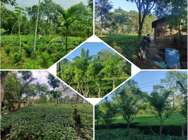
Tea is a major plantation crop in Assam which has significant impact on Economy of Assam and the country as a whole. Availability of a reliable database on the tea gardens is pre-requisite for embarking upon planning strategies for their development. The tea industry in Assam is about 172 years old. Along with the big Tea farming groups or farmers of the state the Small Tea growers also plays a significant role in the overall tea production scenario of Assam. According to the recently conducted door to door survey by the Industries & Commerce Department of Assam, the total numbers of small growers in 14 surveyed districts of Brahmaputra Valley is 68,465. Growth of Small tea growers in five upper Assam district is 64,519 (94%). Dibrugarh and Tinsukia districts of upper Assam have remarkable numbers of small growers and their number is 37,755 (55%). In middle Assam Udalguri, Sonitpur, Nagaon and Karbi Anglong districts have in rising trend. Total area of land under tea cultivation of small growers is 117 thousand acres. Presently, Small growers used patta land as well as other Government land for tea cultivation. In most of the Tea growing districts of Assam 59,717 small gardens have holding size of less than 3 acres. Only 380 small gardens have holding size of 15 acres. The role of the Small Tea growers cannot be ignored in any sense that they contribute a sizeable 400 Million Kg. of tea leaves to the overall production output in annual basis (Industries & Commerce Department, 2019).
Click here